

14 Unknown Facts about Google Maps
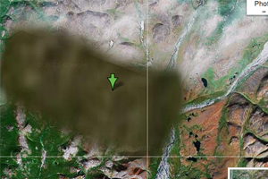 12. How Google hides Private areas in Google Maps?
Those who own the satellites that Google uses may choose to blur certain areas before the satellite and aerial images reach Google. Also, governments can make the satellite owners to blur certain sensitive geographical areas. Street View imagery is only available for public roads and private venues through the Street View Partner Program.
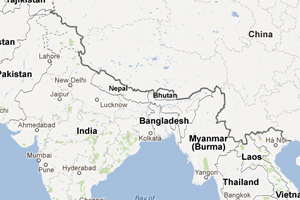 11. China shows some part of India as their own
China has its own localized version of Google Maps named as Google Ditu. In order to be compliant with the requirements of Chinese law, Google had to remove or modify some Google Maps features in Google Ditu. Like it shows the disputed border areas between China and India as being part of China, while on Google Maps those disputed areas are shown inside dotted lines.
 10. Zoom Level


