NASA and ISRO Monitoring Earth's Transformations
By siliconindia
|
Wednesday, 10 January 2024, 20:33 IST


The US-India NISAR collaboration monitors Earth's changes, offering insights into climate, disasters, and agriculture, strengthening global understanding, and fostering diplomacy for sustainable development and environmental stewardship.
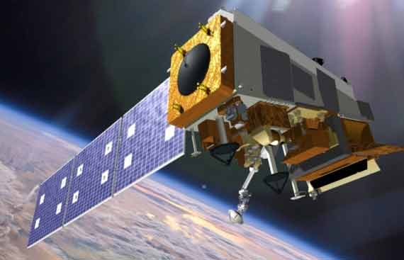
NASA and ISRO have collaborated on a groundbreaking space mission aimed at meticulous Earth observation. The satellite, named NISAR (NASA-ISRO Synthetic Aperture Radar), incorporates advanced radar systems to enhance the comprehension of critical global phenomena such as deforestation, glacier recession, sea ice depletion, and other pivotal indicators of the planet’s health.
NISAR is distinguished by the integration of two radar instruments, one developed by ISRO and the other constructed at NASA's Jet Propulsion Laboratory (JPL) in Southern California. With the ability to penetrate cloud cover and vegetation, the satellite employs radar signals to map almost the earth's entire land and ice surfaces twice every 12 days. This intensive monitoring captures surface movements as fractions of an inch and records alterations in various environmental characteristics. The satellite is currently in its final stages of integration and testing at ISRO's satellite facility in Bengaluru, India, and is slated to launch from ISRO's Satish Dhawan Space Centre in Sriharikota, India, in early 2024.
NISAR's payload is set to house the most advanced radar system ever deployed in a NASA scientific mission, featuring the largest radar antenna of its kind, a drum-shaped wire mesh reflector measuring almost 40 feet in diameter, extending from a 30-foot boom.
The scientific instruments onboard NISAR include L- and S-band radar, named after the wavelengths of their signals. The S-band radar, crafted by ISRO, was transported to JPL in March 2021. Over the past two years, engineers have dedicated their efforts to integrating this instrument with the JPL-developed L-band system and subsequently conducting comprehensive tests to validate their seamless collaboration.
Once operational, NISAR possesses the capability to gather measurements around the clock, irrespective of weather conditions. The treasure trove of data it accumulates significantly enhances researchers' understanding of diverse earth science domains, encompassing landslides, groundwater dynamics, and the intricate processes within the carbon cycle. NISAR is a milestone in NASA-ISRO collaboration, marking the first-ever joint venture for an Earth-observing mission.
The leadership of the U.S. component of the project rests with JPL, managed by Caltech in Pasadena for NASA. JPL contributes the mission's L-band Synthetic Aperture Radar (SAR), while NASA provides critical components, including the radar reflector antenna, deployable boom, high-rate communication subsystem for science data, GPS receivers, solid-state recorder, and payload data subsystem. ISRO plays a pivotal role by supplying the spacecraft bus, the S-band SAR, the launch vehicle, and comprehensive launch services and satellite mission operations.
The US-India partnership through the NISAR project signifies a collaborative effort to monitor the Earth's dynamic changes from space. NISAR's advanced technology promises invaluable insights into climate change, natural disasters, and agricultural patterns. By combining the expertise of both nations, this initiative strengthens global understanding of Earth's processes. The partnership enhances scientific knowledge and fosters diplomatic ties, showcasing the power of international collaboration in addressing shared challenges. NISAR represents a pivotal step toward sustainable development and environmental stewardship on a global scale.