
 Magazine :
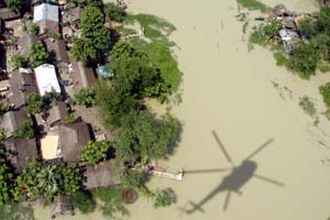
India's Flood-Prone Areas To Be Mapped - But Only By 2022
 He said more observation and monitoring stations will help improve forecast and allow greater time gap in issuing flood warnings.
"The CWC (Central Water Commission) has estimated that there was need for 2,795 hydrological observation stations in the country. There are 878 observation stations at present. We intend to set up 800 more during the 12th Plan period," Sarkar said.
In the case of the Uttarakhand disaster it has become evident that while the state government was warned of heavy rain 48 hours in advance, there was no warning of floods in the affected areas.
Sarkar emphasized there has to be a long term solution to the problem of floods.
He said the impact of floods can be minimised by adopting an optimum combination of structural measures such as large storage reservoirs, detention basins and embankments and non-structural measures like flood forecasting, flood plain zoning and catchment area treatment.
"Better forecasting and inundation plans will help in flood management," he said.
The national water policy 2012 states that flood forecasting is very important for flood preparedness and should be expanded extensively, modernized using real time data acquisition system and linked to forecasting models.
It says that flood inundation maps should be prepared to evolve coping strategies. The policy states that efforts should be towards developing physical models for various basin sections, which should be linked to each other and to medium range weather forecasts to enhance lead time.
The policy also refers to the need of preparation in case of sudden and unexpected flood related disasters.
The policy also notes that protection of all flood-prone areas may not be practicable.

.jpg "Gurbinder Singh Punn: Enabling Leaders To Achieve Unencumbered Success Through Effective Coaching")
.jpg "Navigating Success Presenting Innovative Insights")
