
 Magazine :
10 Places You're Not Allowed To See On Google Maps
Bangalore: Google Maps offers a satellite view or a street-level view of plenty of locations around the world. One can look up landmarks like the Pyramids of Egypt or the Great Wall of China, as well as more personal places, like an ex’s house. But for all of the places that Google Maps allows you to see, there are also places that are off-limits. Google Maps prohibits some images either due to government restrictions, personal-privacy lawsuits or mistakes. Mashable Tech named 10 such places that are blurred and distorted for security reasons.
“The satellite and aerial imagery in Google Earth and Google Maps is sourced from a wide range of both commercial and public sources,” Google spokesperson Deanna Yick was quoted by Masable. “These third-party providers are required to follow the law of the countries in which they operate, so some of them may blur images and then supply us with those images,” he said.
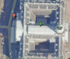 1. The Royal Residence, The Netherlands:
The Royal Palace of Amsterdam in Netherlands, called Koninklijk Paleis Amsterdam is one among a long list of places blurred on Google Maps related to the Dutch royal family. It also includes the Royal Stables that arranges transport for the members of the Royal House and the Royal Household, and another residence called Huis ten Bosch. This address is one of the four official residences of the Dutch Royal Family, and the Queen Beatrix has lived there since 1981.
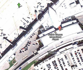 2. Buffalo Niagara International Airport:
The Buffalo Niagara International Airport for the most part is whited out on Google Maps and details can't be seen when the area is zoomed in. This airport is the busiest airport in Upstate New York and the third busiest in New York State by number of boarding’s.


.jpg "Unlocking Potential Redefining Potential & Redefining Excellence")